News Details
Lower Platte South NRD's Flood-Control Network Protects Lincoln and Southeastern Nebraska Communities During Heavy Rainfall
LINCOLN, Nebraska — Heavy rainfall across southeastern Nebraska on Sept. 30, 2026, demonstrated both the power of water and the value of a strong, well-maintained network of flood-control structures. Early planning and close partnerships helped save lives, protect critical infrastructure, and spare neighborhoods and communities from severe flood damage.
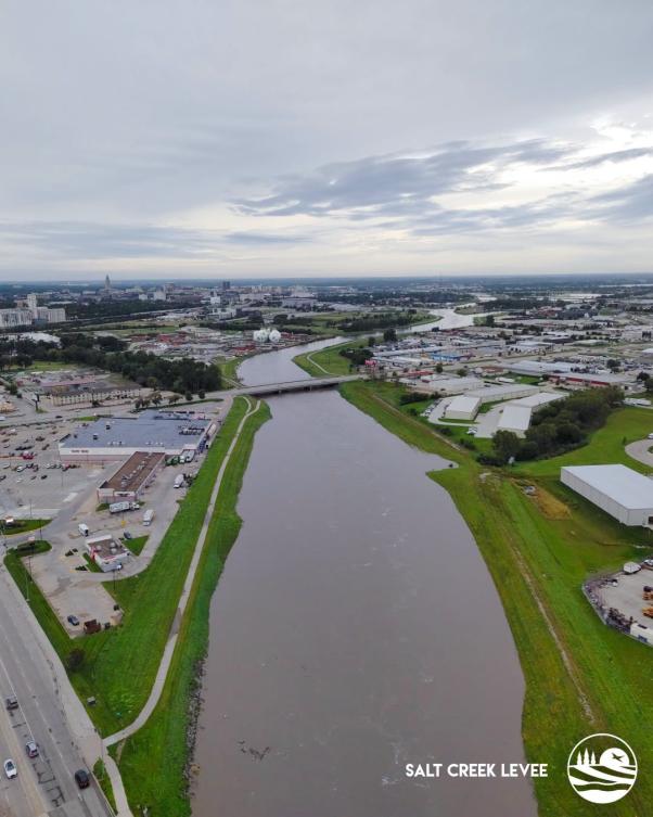
The Lower Platte South Natural Resources District (NRD) operates and maintains the Salt Creek Levee through Lincoln and more than 190 dams designed to reduce flood damage to downstream property and infrastructure. The federal levee system for Salt Creek, the Antelope Valley Project, dams throughout the District, land treatment measures on agriculture land, and other stream stabilization projects proved their value during the extreme weather event on Sept. 30 and Oct. 1. The Lincoln Airport reported 6.15 inches of rainfall Sept. 30, with areas in the Salt Creek Watershed reporting up to 10.41 inches. Lower Platte South NRD serves 715,919 of the watershed’s 1,050,000-acres, and the heavy rainfall tested the District’s flood-control structures.
“The Salt Creek Levee System, Antelope Valley Project, and other flood-control structures demonstrated the value of the public’s investment last week," said David Potter, Lower Platte South NRD general manager. "We haven’t seen that amount of water through Lincoln since 2015, and we are very fortunate to have these critical structures in place. Everything functioned as it should have so that our residents and properties remained safe. We have more work to do in the District and additional flood control structures will only benefit our communities when the next event occurs.”
From the night of Sept. 30 into the following day, Lower Platte South NRD crews worked around the clock to monitor and patrol flood-control structures, identify concerns, and support response efforts. The District’s flood-control system performed as designed, helping protect Lincoln neighborhoods, rural communities, and critical infrastructure while limiting the effects of flooding. That performance—backed by ongoing maintenance and the crews’ rapid response—played an important role in the region’s flood response.
“Our staff did a fantastic and professional job through the night and Thursday morning patrolling the levee and inspecting our other flood control structures to make sure they were performing as they were designed. The entire staff stepped up to inspect our critical structures, coordinate efforts and work with other agencies, and inform the public. I couldn’t be prouder of them,” Potter said.
Protecting people, urban neighborhoods, rural communities, infrastructure, and the broader region remains the District’s highest priority. Following the event, crews continued monitoring conditions and assessing damage to determine the scope of repairs needed. Restoring damaged infrastructure is essential to the recovery effort and to maintaining flood protection against future events.
“Our team continues to assess our structures for damage and plan for needed repairs," Potter said. "We’ll also coordinate with the county, the City of Lincoln, the U.S. Army Corps of Engineers, and the Nebraska Emergency Management Agency."
Since Nebraska’s Natural Resources Districts were established in 1972, they have worked with local, state, and federal partners to construct and maintain flood-control structures that protect lives, property, and critical infrastructure. The Sept. 30 and Oct. 1 events underscored the lasting value of that investment—and the importance of continued collaboration to keep communities prepared and resilient.